

Anderson is located on the plateau of Piedmont, close to the foothills of the Blue Ridge Mountains in Anderson County. The city, also known as the “Electric City,” has numerous national parks to visit and have a good time. This article will help you identify some of the best national parks close to the city. Let’s get to it.
Oconee State Park
Oconee State Park is situated in the Blue Ridge Mountain region of South Carolina. The park, which sits on 472 acres of land, offers its visitors several recreational activities ranging from boating, camping, fishing, hiking, and picnicking. In addition, the park also provides cabins and meeting facilities to its visitors. The park was created by the CCC, Civilian Conservation Corps, around 1930. Commendably, some of the buildings in the park were set up by the Civilian Conservation Corps. It is important to note that the CCC created the park during the Great Depression, where men were made to work on civilian projects by Franklin Roosevelt. Oconee State Park has all the attributes you could ask for from a relaxing park. It also has several trails for biking and running, such as the Foothills Access trail, Hidden falls trails, Lake Trail, and the Oconee trail. The park is usually open from 7 a.m. to 7 p.m. from Sundays to Thursdays and from 7 a.m. to 9 p.m. on Fridays and Saturdays. It is important to note that pets are only allowed in cabins 14-20 of the Oconee State Park. In addition, it is strictly advised to keep pets on a leash, less than six feet, when outdoors.
Sadlers Creek State Park
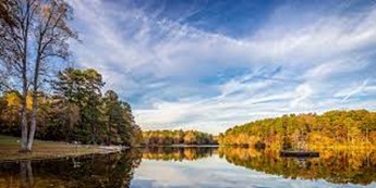
Sadlers Creek State Park is situated close to Anderson in Anderson County, South Carolina. It sits on 395 acres of land, approximately 2km2 of land area. The park sits on a peninsula that lengthens into Hartwell Lake. The park offers exciting activities to its visitors, such as; fishing, biking, hiking, boating, bird watching, picnicking, and geocaching. The Sadlers Creek Park boasts picnic shelters, two playgrounds, a boat ramp, and a 5.4-mile bike trail. In addition, the park also offers a pavilion by the lakeside for large gatherings. The roads in the park are paved and in good condition. The top trails available in the park are two, namely, Sadlers Creek Bike Trail and Sadlers Creek Pine Grove Nature Trail. Sadlers Creek State Park opens every day of the week from dusk to dawn.
Calhoun Falls State Park
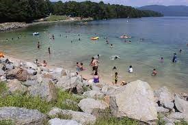
Calhoun Falls Park is situated along the shores of Lake Russell, close to Calhoun Falls in Abbeville County, South Carolina. It sits on 318 acres of land, about 1km2 in area. Activities offered by the park include camping, picnicking, hiking, fishing, biking, and swimming. It features a playground, picnic shelters, one basketball court, a boat ramp, and a park store. The park’s office rents fishing rods and reels for fishing enthusiasts. The park allows visitors to bring along their pets as long as they are kept on a leash less than six feet. In addition, owners of noisy or malicious pets will be asked to remove them to avoid intimidating other pets or wildlife. The park also features a 1.75-mile-long trail known as the Cedar Bluff Nature Trail. Since the park is located on Lake Russell, it provides visitors access to the 26,650-acre lake, the park’s core feature.
Tugaloo State Park
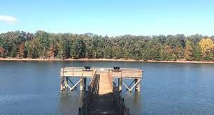
Tugaloo State Park is situated along the shoreline of Lake Hartwell in Franklin County. It is located on a wooden peninsula, sits on 393 acres of land, and offers boat ramps, bounteous fishing grounds, and a swimming beach. In addition, visitors can also engage in the following activities.
- Geocaching
- Hiking
- Horseshoes
- Tennis
- Weddings (park approval is a requirement)
- Miniature Golf (Fee)
From the park, visitors can have any view of the 55,590 acres of Lake Hartwell. The park has a six-lane ramp that is used for large fishing competitions. The park’s name “Tugaloo” is an Indian name for the river that used to flow in the area before Hartwell Dam was built. In addition, the park is forested with a different mix of pines, oaks, and hickories, not to mention the flowering dogwood, sweetgum, and black cherry that yield large volumes of wildlife food.
Devils Fork State Park
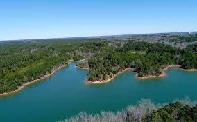
Devils Fork State Park is located in the northwestern part of South Carolina at the edge of Lake Jocassee, a 7,500-acre lake on the eastern edge of the Sumter National Forest. The park is just three miles off the Cherokee Scenic Highway. The park offers kayaking, hiking, canoeing, and camping activities. Devil Fork Park is well known for its fish species, including rainbow and brown trout, alongside the smallmouth and the largemouth species. The park’s size is about 622 acres and translates to about 2.5km2. The park was created in 1990 and serves as a habitat for about 90% of the world’s Oconee Bell population. The Oconee Bell is an indigenous North and South Carolina flower. The flower, pink and white, grows throughout the park. In addition, the park has the following campsites.
- Regular campgrounds
- Primitive boat-in
- RV sites
Caesars Head State Park
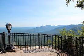
Caesars Head State Park is located in Greenville County, South Carolina, and it borders Transylvania County of North Carolina. The park currently covers approximately 7,467 acres of land and was created from 1976 to 1986. Though the origin of the park’s name, Caesars Head, is uncertain, it is thought that it was probably named after an early mountaineer’s dog. Together with the Jones Gap State Park, the two parks are managed by the state Department of Parks, Recreation, and Tourism. The park is mainly known for its view of the mountain country. In addition, the park also features a hiking trail leading to the 128meter-high Raven Cliff Falls. Fishing is one of the most common activities in the garden, primarily done in the Middle Saluda River and creeks of Julian and Matthews. The park also has its visitor center containing photographs that explain the park’s human antiquity and a relief map of the whole Mountain Bridge Wilderness Area.